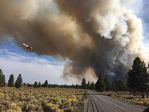
CENTRAL OREGON –
The Tepee Fire on the Deschutes National Forest is now estimated at 2,000 acres with 0% containment. Gusty winds caused the fire to spot outside fire lines today and dozers and Single Engine Air Tankers quickly responded, holding the spot to approximately 50 acres. Firefighters were able to put in fire line around the entire fire with dozers, crews and retardant and will work tonight and tomorrow to hold and improve the line and continue mopping up. The Deschutes National Forest has issued an area closure for the area around and adjacent to the fire area, including the northwest section of the East Fort Rock OHV Trail System. For a map of the closure area, visit: centraloregonfire.org
Terrain on the Willow Fire is still challenging firefighters with steep slopes, rollout from rocks and heavy fuels. The fire is now estimated at 400 acres and the BLM remains in unified command with Jefferson County to manage the fire burning south of Pelton Dam and Willow Canyon, approximately 6 miles north of Madras. Helicopters cooled hot spots as hotshots worked to put in containment lines on the north and east perimeters of the fire. The fire remains 20% contained and Pelton Park Campground is under a Level 3 evacuation as is the surrounding area and NW Pelton Dam Road. A Level 1 evacuation is in place for Elk Drive, although the road is closed to the public.
Investigations revealed that the Tepee Fire was caused by an abandoned campfire. The public is reminded to heed all public use restrictions as central Oregon is still in EXTREME fire danger and campfire restrictions remain in effect. For more information on public use restrictions in central Oregon, visit: https://www.fs.usda.gov/alerts/deschutes/alerts-notices
####