Prescribed fires are carefully planned and implemented by fire-management professionals in areas where forest restoration is most needed and wildfire risk is greatest, which means it is a tool often used in the forests immediately surrounding our communities, our homes, and the places we love in the forest.
Prescribed burning is primarily done in the spring and fall. Whenever fire is used deliberately as a tool to improve the health of the forest and increase community and firefighter safety, it requires careful planning and is conducted under prescribed conditions of temperature, wind, and humidity. This ensures they accomplish the desired ecological outcomes and can be safely controlled, all while reducing the likelihood that heavy amounts of smoke will blow into nearby communities.
Prescribed fires are planned and implemented in areas where forest restoration is most needed and where the risk of out-of-control wildfire threatens what we value in our forests and in our communities. Frequently these are forests surrounding our communities (often referred to as the Wildland Urban Interface, or WUI), highly-used recreation areas, and boundaries with private property. It’s in these locations that are the highest priority for prescribed burning to reduce the severity and intensity of future wildfire, while also restoring healthy forest ecosystems in our backyard.
Interactive Prescribed Fire Map
You can find out where to expect prescribed fires in Central Oregon by using our interactive prescribed fire map. PLEASE NOTE: In most cases, the pile burning units are not included on the map below.
MAP KEY
Red: burn is imminent or has just been completed
Black: burn is complete and is being monitored
Green: burn is in a stage of planning.
New tools are also being developed that improve our ability to forecast where prescribed fire smoke may travel based on the location of the fire, predicted weather, topography, and other factors. And while not perfect, they do provide a helpful resource to better understand what areas may be impacted by smoke.
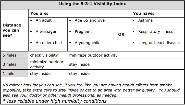
If you want to know if you will be impacted by prescribed fire smoke, use the Oregon DEQ Air Quality Index map below to view current air quality conditions. Please note, due to the limited availability of air quality monitors in Central Oregon, these monitoring networks do not capture air quality conditions in all communities. You can also utilize the 5-3-1 Visibility Index for more information.