Beachie Creek Fire Update for Monday, September 14, 2020
Salem, Ore. – Firefighters will resume work on Monday to secure the perimeter of the Beachie Creek Fire. Crews and heavy equipment
are working to tie the pieces of existing control line together on the west and northwest portions of the fire. Line construction and reinforcement efforts which began Saturday south of Highway 22 will continue.
Firefighters continue to work with landowners on the southeastern perimeter of the fire to build and secure control lines in that area. Firefighters began mopping up and systematically assessing damage to structures inside the fire on Sunday and will continue those efforts today.
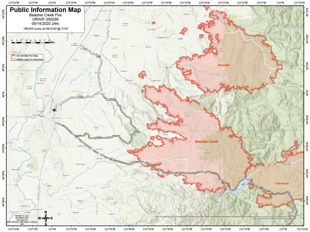
The Beachie Creek Fire and the Riverside Fire remain about one mile apart.
Officials from nearby fires are coordinating strategies to minimize fire growth and stabilize incidents. The combination of winds, record dry forests, and a lack of natural holding features in the Table Rock Wilderness and surrounding areas mean it is still possible the fires could burn together. Based on current weather, it is anticipated that a future merger would not result in dynamic fire behavior as seen last week.
Fire officials are working closely with the Marion County Sheriff’s Office, ODOT and the Oregon State Police to coordinate recovery efforts along the Santiam Canyon. Currently 16,776 structures are at Level 3 evacuations and another 18,528 homes in level 2 evacuations. It is imperative to protect first responders and communities in the path of the fire that everyone heeds fire and law enforcement road closures and evacuations. Anyone who enters the fire perimeter jeopardizes firefighting and rescue operations, puts
lives at risk, and potentially increases the time it will take to return residents to their communities.
WEATHER: Valley inversions are likely to persist through the day again. High temperatures Monday will generally be in the upper 60s to low 70s, with forecast minimum relative humidity of 45-55 percent on the west side of the fire. Relative humidity is expected to be much lower, 30-45 percent, on the east side of the fire and at elevations above 2,500 feet. The weather pattern is predicted to change in the next 24 hours, with a chance of rain on the west side of the fire.
SAFETY: Members of the public are encouraged to heed local evacuation orders issued by the county sheriff’s office and emergency notification systems. Know the Ready, Set, Go levels and make appropriate preparations. READY your belongings; SET your things at the door or prepack them in your car; GO and leave immediately.
SMOKE: Smoke will continue to be heavy across the area of the Beachie Creek Fire again today. This will lead to “unhealthy” and possibly “hazardous” conditions. Individuals with respiratory issues may find themselves affected by the intense smoke. Areas closest to fires – near Detroit, Florence, and Eugene – will have severe smoke impacts. Smoke levels can change rapidly depending on weather.
Check current conditions on DEQ’s Air Quality Index or by downloading the free OregonAIR app on your smartphone.
CLOSURES: Willamette National Forest roads, trails, and lands around the fire area are closed. View the official order (Order 06-18-04-20-13). Bureau of Land Management (BLM) lands in the vicinity of the fire and State lands managed by Oregon Department of Forestry (ODF) including the Santiam State Forest are also closed to the public. Go to InciWeb (link below) for a list and map of closed areas, roads, trails, and recreation sites.