BEACHIE CREEK FIRE UPDATE – September 24, 2020
Acres: 192,838 acres Percent Containment: 49%
Start Date: August 16, 2020 Cause: Under Investigation
Origin Location: Opal Creek Wilderness: Fuels: Timber and logging slash
two miles south of Jawbone Flats, Resources: 801
six miles north of Detroit, Oregon. Flights:Temporary Flight Restriction
No expansion of the Beachie Creek fire
Rain slows fire activity Thursday
Salem, Ore. – The Beachie Creek fire will respond favorably to the continued rainfall. Heavy cloud cover, high humidity, and showers slow fire activity and subside smoke.
Wet conditions can also cause dangers in the coming days. Drivers must recognize and be aware that there are numerous hazards present in both urban and rural driving environments. Yield to first responders. As ground moisture increases, fire-weakened trees could topple, and rock and mudslides are possible.
There was no expansion of the fire perimeter on Wednesday, though heat sources remain inside of the boundary. Fire has been smoldering underground burning tree roots and creating cavities filled with hot ash as deep as seven inches and a hot as 1,200 degrees. At these locations, crews worked Wednesday to expose the deep ash pits so today’s rain can penetrate the heat, but it will take steady rain over long periods to end the fire.
After assessing hazards, crews will adjust their level of direct engagement under trees. Most work on Thursday will occur along the Highway 22 corridor where firefighters will monitor the fire and mitigate hazards for residents. A crew dedicated to protecting structures will also continue working in the North Santiam River and Elkhorn areas. Timber contractors are securing a control line in the 14-mile unburned area to the east of Silver Falls State Park.
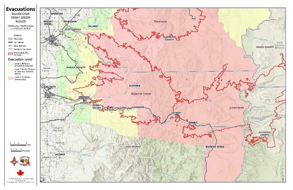
The Marion and Linn County Sherriff Offices continue to evaluate and lower evacuation levels but are asking residents to stay connected with their websites and alerts:
- Marion County Sherriff’s website / evacuation maps: https://marioncounty.maps.arcgis.com/apps/webappviewer/index.html?id=5202b602f99647b9a16d488c545113b5
- Linn County Sheriff’s website here:https://linngis.maps.arcgis.com/apps/webappviewer/index.html?id=56668b1f57cf4bec9be88420a37e1183
The Willamette National Forest, Bureau of Land Management, and State lands around the fire remain closed to the public. Go to InciWeb.gov for more information about closures in the area.
| Public Contact Information: Facebook.com/BeachieCreekFire2020 Email: [email protected] Phone: 541-583-0526, 8 a.m. to 8 p.m. | Inciweb https://inciweb.nwcg.gov/incident/7001/ Smoke and Air Quality https://oregonsmoke.blogspot.com/p/air-quality-now.html https://wildlandfiresmoke.net/outlooks |