Size: 51,814 acres
Contained: 12%
Start Date: August 1, 2022
Location: 15 miles E of Oakridge, OR
Cause: Lightning
Total personnel: 862
Resources: 29 engines | 19 crews | 46 heavy equipment |8 helicopters
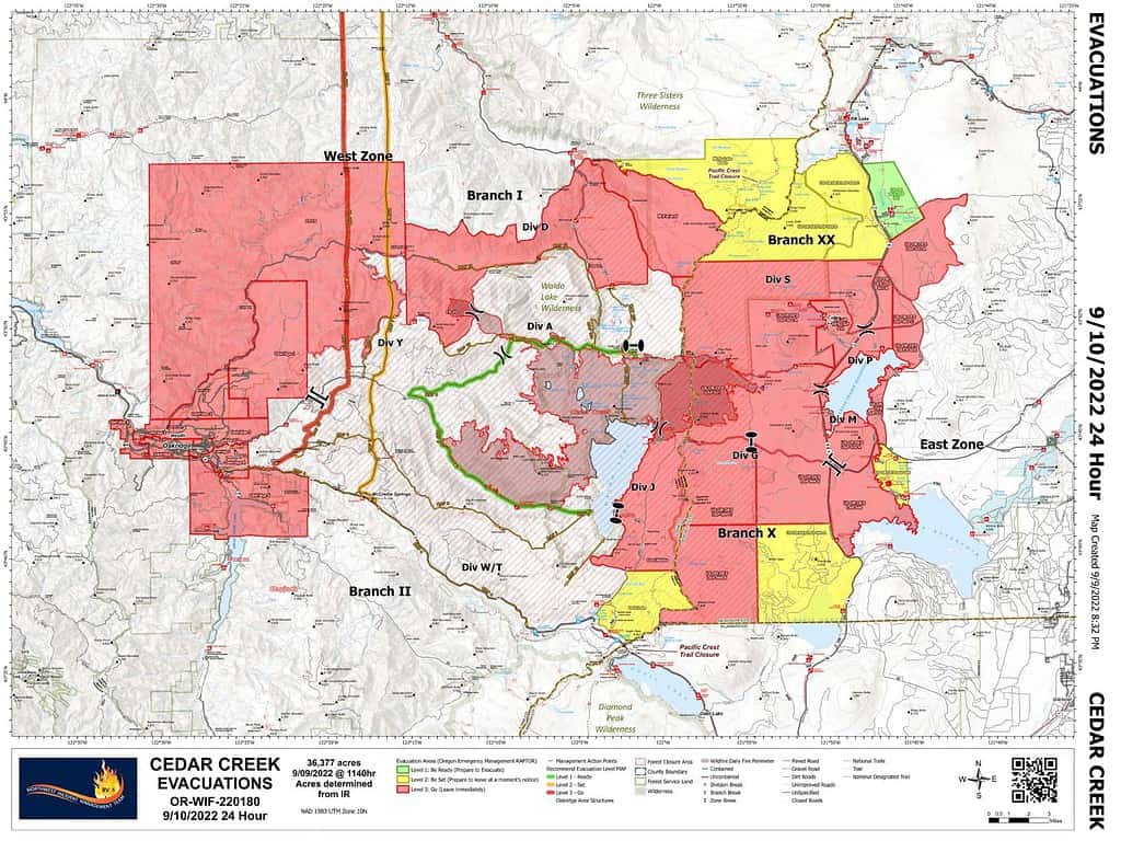
Current Situation: Yesterday, Governor Kate Brown invoked the Emergency Conflagration Act. Level 3 evacuation level remains in place for the greater Oakridge, Westfir, and High Prairie area. Fire activity is expected to be high again today. East winds, low humidity, and high temperatures will continue today and start to ease tomorrow. Where winds align with terrain, tree canopy fire and fire spotting are anticipated. Fire will be carried by lichens and heavy fuels.
Status of the fire on the Willamette National Forest and West Zone: The fire has not crossed west of Highway 19; firefighters are working to hold and improve the east side. Spot fires crossed south of Highway 58 at Kitson Ridge. Firefighters are working to keep the fire north of Forest Road 1928.
Today’s fire activity is expected to be extreme with long-range spotting and crown runs. Expect a large smoke column to develop by mid-morning.
East of Waldo Lake: the Alaska Incident Management Team has established two branches and six divisions to work in the Deschutes National Forest side of the Cedar Creek Fire. Where possible, direct attack water drops with helicopters is occurring on the southeast edge. Crews are preparing Road 4290 from Charlton Lakes to the Cascade Lakes Highway to control the spread of the fire to the southeast. To prevent the spread of the fire toward the east, efforts are focused on shaded fuel breaks 100-200 feet in depth on both sides of the Cascade Lakes Highway. Crews are working in the Brown Mountain area south of Crane Prairie Lake and working north. From the north, crews are working from the 2017 Nash Fire burned area near Elk Lake and improving the fuel breaks on both sides of the Cascade Lakes Highway working south. Additional contingencies are being scouted for east of the Cascade Lakes Highway.
Weather: A RED FLAG Warning is in effect today due to hot, dry, and windy conditions. East winds will continue today and switch to westerly winds tomorrow. Toward the afternoon the valley will become windy. Poor humidity levels overnight will allow for an extended burn window.
Closures: The Deschutes National Forest and Willamette National Forest have implemented closures for the Cedar Creek Fire. Please visit Willamette National Forest and Deschutes National Forest for detailed closure orders and a joint map. A Temporary Flight Restriction (TFR) is in place. The use of drones is prohibited in the fire area, please make it safe for our firefighters to use aircraft on the fire. Pacific Crest Trail hikers should visit pcta.org for current information.
Restrictions: Fire restrictions are in place on the Willamette National Forest and Deschutes National Forest.
Smoke: Smoke Forecast Outlooks are available at https://outlooks.wildlandfiresmoke.net/outlook.
Online: https://inciweb.nwcg.gov/incident/8307/ | https://www.facebook.com/CedarCreekFire2022/ |
YouTube: https://www.tinyurl.com/cedarcreekfireyoutube
Fire Information: 8:00 AM – 8:00 PM | Phone: 541-201-2335 | Email: [email protected]
Evacuations: Sign-up for emergency mobile alerts by going to oralert.gov Please check with Lane County Sheriff’s Office 541-682-4150 and Deschutes County Sheriff’s Office 541-693-6911 for updates and changes. Go to https://bit.ly/3D51kvC to view a map or see below.