Friday, September 22, 2023 – Morning Update
Current Status:
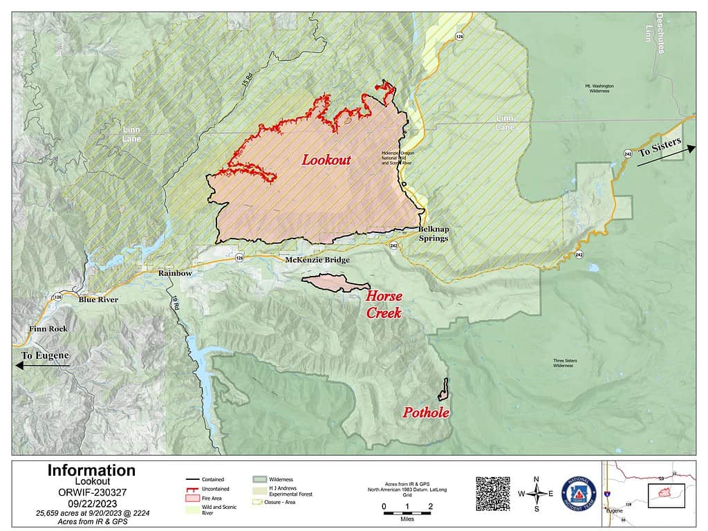
Lookout Fire: Size: 25,659 acres l Start Date: August 5 l Cause: Lightning l Containment: 50%
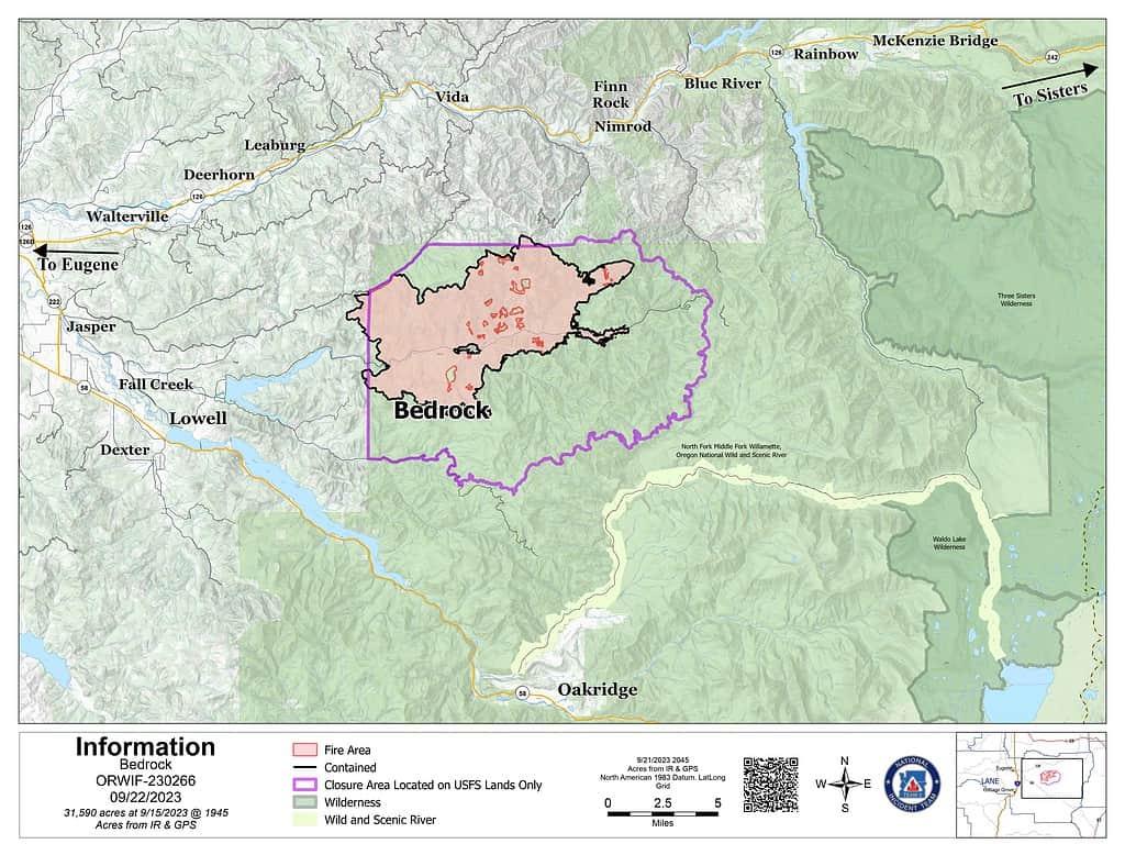
Bedrock Fire: Size: 31,590 acres l Start Date: July 22 l Cause: under investigation l Containment: 98%
Petes Lake Fire: Size: 3,144 acres l Start Date: August 25 l Cause: Lightning l Completed: 50%
Horse Creek Fire: Size: 763 acres l Start Date: August 24 lCause: Lightning l Containment: 100%
Pothole Fire: Size: 109 acres l Start Date: August 25 l Cause: Lightning l Containment: 100%
Total Personnel: 857
Total Assigned Resources: 29 engines l 19 crews l 7 dozers l 28 water tenders l 5 masticators l 8 helicopters
Suppression: Due to the moderate weather and minimal fire movement, indirect suppression activities have been reduced on the Lookout Fire and Petes Lake Fire. In the northern area of the Lookout Fire, a tub grinder has been deployed. This specialized equipment processes woody debris, turning it into mulch to reduce the orientation of fuel and, therefore fire behavior potential. Meanwhile, hotshot crews will hike into the Petes Lake Fire to monitor the fire’s behavior from the ground. To mitigate future fire risks, crews will continue fuels reduction activities, involving thinning and chipping around day use areas at Elk Lake and Quinn Meadow Horse Camp. Additionally, efforts continue along the Crescent Lakes Highway and Forest Road 4628, near the Deschutes Bridge and Cascade Lakes Highway junction. This work is focused on mastication and chipping to reduce fuels and enhance safety. Containment lines on Horse Creek Fire and Pothole Fire are being monitored to ensure the fire remains within its established footprint.
Suppression Repair: With the low fire activity across all fires, suppression repair efforts remain the main component of our operations, addressing the environmental impact caused during initial suppression activities. The Bedrock Fire included 21.2 miles of National Forest System trails, campgrounds, and day use areas along Fall Creek. Crews are working through repair suggestions provided by Resource Advisors on the northern end of the Bedrock Fire and southern areas of the Lookout Fire. Some key aspects include identifying and removing fire weakened trees along roadways, clearing woody debris from the forest floor to assist in ecological recovery, backhauling hose lay and equipment, stabilize soils on dozer and hand lines to prevent soil erosion, and ensuring the ditches and culverts are clear for the upcoming rain. Repair work is essential for the safety of forest users, prevents roads from washing out, reduces fuel loading for the future, and protects stream health and will continue long into the future.
Burned Area Emergency Rehabilitation (BAER): The BAER team released an assessment of the Bedrock Fire yesterday afternoon, which outlined both short-term and long-term recovery concerns. The soil-burn severity map for the Bedrock Fire identifies 10.8 percent of the fire area as having high burn severity and 28.5 percent with moderate burn severity. The remaining 60.7 percent has low or very low burn severity. By using the burn severity map, BAER scientists calculate expected increases in stream flows and run models to identify areas prone to erosion or landslides, these findings provide information needed to prepare and protect against post-fire threats identifying areas for immediate repair within 1 year of fire containment.
Linn County Evacuations: Visit the Linn County Wildfire map for current evacuation information.
Lane County Evacuations: Visit the Lane County Lookout Fire Evacuation Areas map for current evacuation information.
Deschutes County Evacuations: Visit the Deschutes County Emergency Information map for current evacuations information.
Forest Closures: Emergency closure orders remain in place for the Willamette National Forest and the Deschutes National Forest. For information on Oregon hunting regulations and these forest closures, contact Oregon Department of Fish and Wildlife at (503) 947-6000.
Restrictions: Fire Restrictions are in placeon the Willamette National Forest and Deschutes National Forest. Temporary Flight Restrictions remain in place over the Bedrock and Lookout Fire areas.
Smoke Outlook: A smoke outlook for West-Central Oregon includes the Lookout, Bedrock, Petes Lake, Horse Creek, and Pothole Fires. Another source for air quality information is the Fire and Smoke map from airnow.gov.
Fire Information:
Email: [email protected]
Phone: 541-215-6735 (8 a.m. – 8 p.m.)
Facebook:
InciWeb:
Lookout Fire Information: 541-215-6735, [email protected]