Central Oregon — Yesterday firefighters on the Jackpine Fire burning on Prineville District Bureau of Land Management lands approximately one and a half miles southwest of La Pine, south of Masten Road and west of Highway 97 kept the fire within its existing footprint. Today they will continue to strengthen lines around the perimeter of the fire and start working their way interior extinguishing hot spots. The Jackpine Fire remains 180 acres and is 15% contained.
Resources currently assigned to the Jackpine Fire include 2 Type 2 initial attack crews, 1 Type 2 crew, 11 engines, 2 dozers, 1 water tender and overhead resources. The cause of the fire remains under investigation.
The Deschutes County Sheriff’s Office has issued Level 2 (Get Set) evacuation notices west of Highway 97 and south of Masten Road to the county line. Stay up-to-date with Deschutes County Sheriff’s Office evacuations using their interactive map available here. Klamath County Sheriff’s Office issued a Level 1 (Be Ready) for both sides of Highway 97 south of the Deschutes County line including Long Prairie. Visit Oregon Department of Transportation’s TripCheck.com for current information on Highway 97.
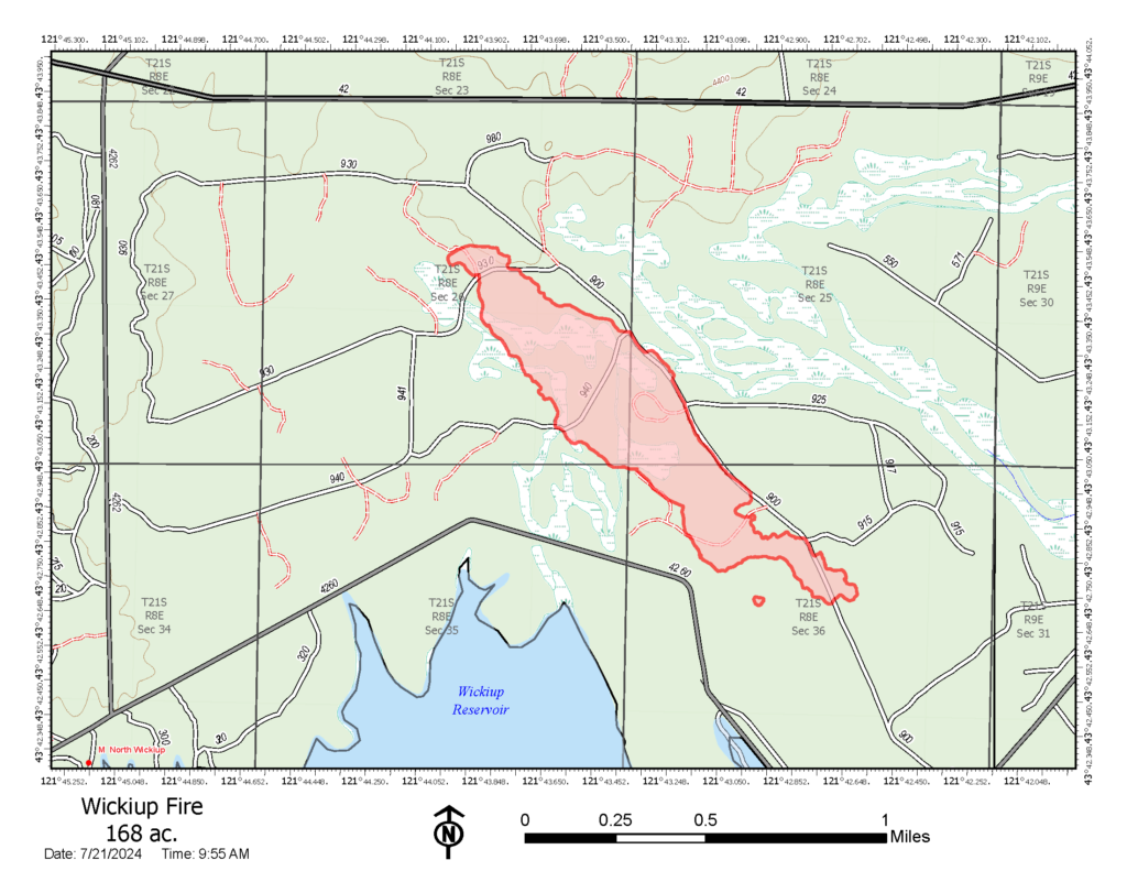
Firefighters continue to make good progress on the Wickiup and Round Mountain Fires burning on the Deschutes National Forest. The Round Mountain and Wickiup Fires are burning approximately seven miles northwest of La Pine and just north of Wickiup Reservoir. A Central Oregon Type 3 Team is managing both incidents.
Yesterday firefighters on the Wickiup Fire spent the day mopping up and securing lines around the perimeter of the fire. Today resources will continue to use equipment and water to secure and strengthen lines to keep the fire in its current footprint. The Wickiup Fire has been more accurately mapped at 168 acres and is 20% contained.
Firefighters on the Round Mountain Fire worked through the night to bring fire to places where indirect line had been constructed. Bringing fire to the edge of the control line removes vegetation between the fire’s edge and the line decreasing the chance that fire behavior will increase and potentially spot over control lines. Today firefighters will use water and equipment to secure the perimeter of the fire and mop-up hot spots. The Round Mountain Fire is estimated at 108 acres due to fire progression and burnout operations and is 5% contained.
Resources on the Wickiup and Round Mountain fires include 5 handcrews, 6 engines, 3 dozers, 4 skidgeons, 2 water tenders, 4 fallers, and overhead resources. Both fires are under investigation.
The Deschutes County Sheriff’s Office has issued Level 3 (Go Now), Level 2 (Get Set) and Level 1 (Be Ready) evacuation notices north of Wickiup Reservoir. An interactive map of evacuations is available here:
- Level 3 (Go Now): National Forest area north of Wickiup, Forest Service Road 4262 and Forest Service Road 4380 and south of Forest Service Road 42 (South Century Drive)
- Level 2 (Be Set): National Forest area between Road 4380 and the Deschutes River including Bull Bend and Wyeth Campgrounds and private inholdings along the west side of the river at Haner Park
- Level 1 (Be Ready): Haner Park subdivision east of the Deschutes River
The Deschutes National Forest has issued area emergency closures for both the Wickiup Fire and the Round Mountain Fire. Bull Bend and Wyeth Campgrounds and Tenino Boat Launch are currently closed. North Twin Lake Campground remains closed and is being used to support firefighting operations.
A red flag warning is in effect for much of Central Oregon today for abundant lightning and gusty outflow winds.
Visit the official source for wildfire information in Central Oregon at centraloregonfire.org for wildfire updates or follow fire information on X/Twitter @CentralORfire. Call 9-1-1 to report a wildfire.
# # #