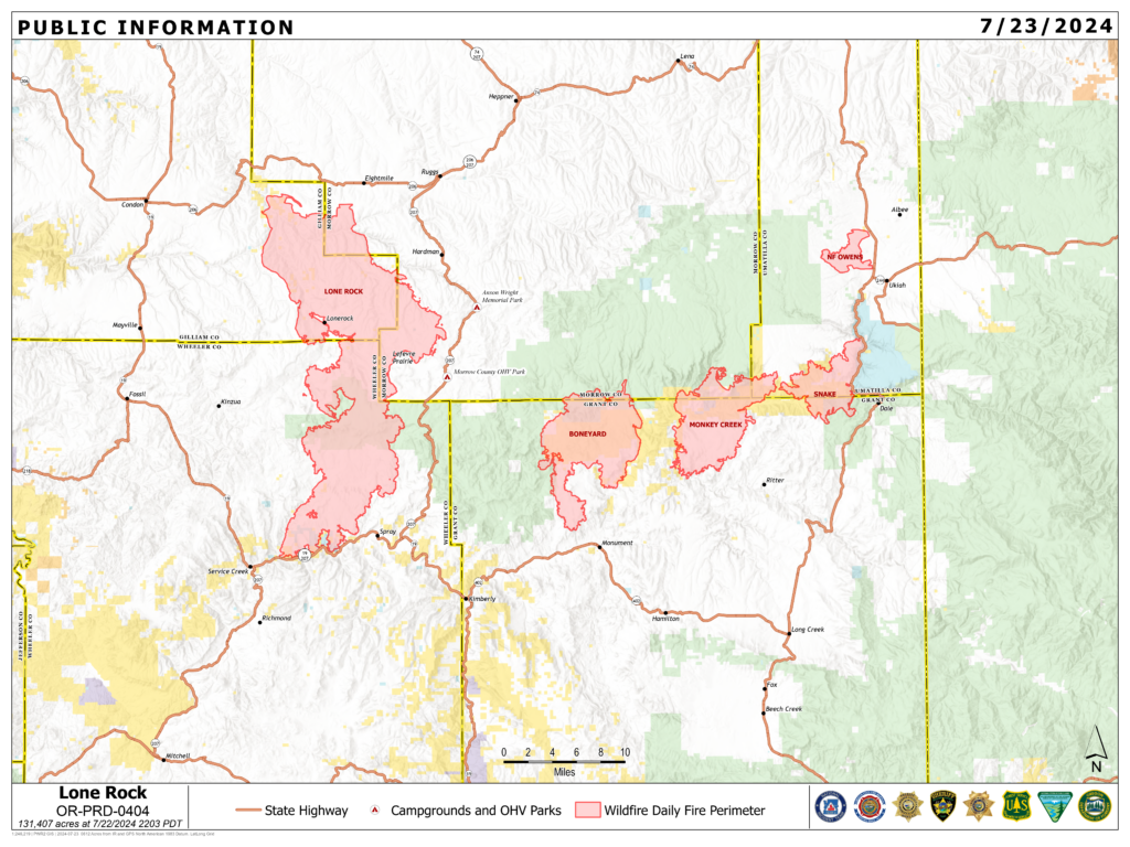
Location: Lonerock, Oregon to west of Hwy 207| Size: 131,407 acres | Containment: 40%
Cause: Under Investigation | Start Date: July 13, 2024 | Total Personnel: 876
InciWeb: https://inciweb.wildfire.gov/incident-information/orprd-lone-rock-fire
Fire Information Line: 541-208-4369 | Email: [email protected]
Condon, Oregon — The Lone Rock Fire is being managed under a full suppression strategy by the unified command of the Northwest (NW) Team 2 and Oregon State Fire Marshal (OSFM) Red Team.
Yesterday’s Activities: Planned firing operations to secure indirect line resulted in mixed results based on terrain and fuel conditions along the fireline. Crews tasked with securing the fireline south of Forest Service Road (FSR) 21 conducted test ignitions and found conditions unfavorable to proceed with firing. However, these crews successfully conducted mop-up activities along the eastern edge of the fire from FSR 21. Conditions near the junction of Alder Creek Road and Highway 19 proved more favorable for firing operations. Terrain-driven, up canyon winds assisted in pushing flames in the direction of the fire activity; helping to reinforce planned holding features.
With the establishment of a forward operating base in Spray, Ore., firefighters are better positioned to meet their goal of protecting structures and the community. Additionally, the OSFM task forces were bolstered by two additional task forces from Utah. Crews continued to establish and reinforce holding features along the fireline to the north and west of the community. Two task forces were mobilized to the Boneyard Fire to support structural protection near the town of Monument, Ore.
Crews along the eastern fireline north of FSR 21 worked to extend pre-existing containment line south with mop-up activities. Along the western fireline south of Lonerock Road, strong northerly winds tested the line. Crews worked to hold the existing line and began developing contingency lines to the north. Structural task forces began structure assessment to the north of Lonerock Road to ensure appropriate protections are in place if winds push the fire beyond its current perimeter. Crews patrolling the northern perimeter of the fireline and the community of Lonerock, Ore. continued to observe no changes in fire activity.
Cooler evening temperatures supported night crews with continuing firing operations along Alder Creek. Crews worked to connect the fireline south to Highway 19.
Today’s Activities: Firefighters working along the eastern edge will continue to build direct control lines in efforts to extend from Burton Hill south to FSR 21. Additionally, indirect contingency line is being improved adjacent to Highway 207 south of FSR 21 to the north of FSR 25 in efforts to secure the fireline near Flat Iron Springs.
The two task forces that mobilized to the Boneyard Fire yesterday will return to the Lone Rock Fire today. An additional task force is arriving from Marion County bringing the total number of task forces to 14. Firefighters with OSFM will focus on supporting firing operations on the southern portion of the fire, protecting homes along Highway 19, and accessing structural impacts in areas that were previously inaccessible.
Firefighters plan to continue burnout operations to connect existing lines to the west of Spray, Ore. in Alder Creek, and along Lonerock Road. Point protection will continue along Highway 19 while crews work to ensure any unburned areas no longer pose a threat to structures in the area.
Burning operations will continue along the western fire perimeter to improve and connect control lines. Aerial ignition may be used to introduce fire in a controlled manor in the open flats near Notch Road. Aerial ignition utilizes a plastic sphere dispenser (PSD), a machine that releases plastic balls used to ignite natural material on the ground. PSD use could support ongoing efforts to connect fireline along the western edge from FSR 21 to FSR 25.
Along constructed control line, crews will proceed with mop-up activities to build containment. Task forces will work West of Cambell road to conduct structure assessment and clear the area of hot spots. Firefighters will continue patrols along the 40 percent of containment for any changes in fire activity.
Evacuations:
- Level-3 Evacuations – GO NOW! Level-3 Evacuate immediately for the following areas:
- Gilliam County: residences South of Lonerock. For more information on evacuations, visit Gilliam County Sheriff’s Office Facebook page.
- Wheeler County: HWY 19 at Rowe Creek Road, south on Rowe Creek Road to Twickenham Bridge, to HWY 19 at Girds Creek, east to the county line, north of the county line to Morrow County line, west on the northern county line, south through the Kinzua area, south back to Rowe Creek Road. For more information on evacuations, visit Wheeler County Sheriff’s Office Facebook page.
- Morrow County: from the West County Line along Buttermilk Canyon to HWY 207, Mile Post 10 south of Hardman to the south Morrow County line. The Red Cross will be setting up a temporary shelter at the Heppner Elementary School. For more information on evacuations, visit Morrow County Sheriff’s Office Facebook page.
- Level-2 Emergency Alert – GET SET! Level-2 Be set to evacuate at a moment’s notice for the following areas:
- Gilliam County: residences north of Lonerock. For more information on evacuations, visit Gilliam County Sheriff’s Office Facebook page.
- Wheeler County: HWY19/Rowe Creek to Twickenham then Girds Creek/HWY 207 S, south on HWY 207 to Cherry Lane west to the Grant County line. For more information on evacuations, visit Wheeler County Sheriff’s Office Facebook page
Shelters:
- An evacuation center has been set up at the Wheeler High School (600 E B Street, Fossil, Ore.). A large animal shelter is available at the County Fairgrounds (720 E 3rd Street in Fossil, Ore.).
Closures:
- OR-19 is closed between milepost 78.7 to milepost 95.2. For updated road closure information, visit https://www.tripcheck.com/.
- Umatilla National Forest Order Number 06-14-02-24-01 affects all National Forest System lands, trails, and roads that lay within the Proclamation Boundaries of the Umatilla National Forest and reside within Wheeler County.
- Umatilla National Forest Order Number 06-14-02-24-02 includes prohibitions within the Heppner Ranger District on the Umatilla National Forest.
- Bureau of Land Management Prineville District Office issued an Emergency Public Land Closure on BLM-managed lands along the main stem John Day River from Kimberly, Ore. To Dale, Ore.; and along the North Fork John Day River from Kimberly, Ore. to Dale, Ore.
Weather: Northerly winds are likely to continue through mid-week with a slight decline in gusts speeds from a maximum ridgetop speed yesterday of 25 mph to 12 mph by Wednesday. Terrain-driven winds are likely to continue to push up canyon and may lead to column growth. Warming temperatures will bring lower relative humidity. The incident meteorologist installed a mobile weather collection station at the forward operating base in Spray, Ore. The station allows access to real-time weather data to help fire behavior predictions and inform firefighting operations.
Smoke Information: Visit https://fire.airnow.gov/ for local air quality information.
Flight Restrictions: A Temporary Flight Restriction (TFR) is in place above the Lone Rock Fire area. If you fly, we can’t. Unauthorized drone flights (UAS) pose serious risks to firefighter and public safety and the effectiveness of wildfire suppression operations. Aerial firefighting is suspended when unauthorized UAS are in the area, allowing wildfires to grow larger.