Size: 82,947 acres Location: South Fork of the John Day River; Grant, Crook, Wheeler Counties
Start Date: Sep. 2, 2024 Containment: 0% Cause: Lightning Total Personnel: 500
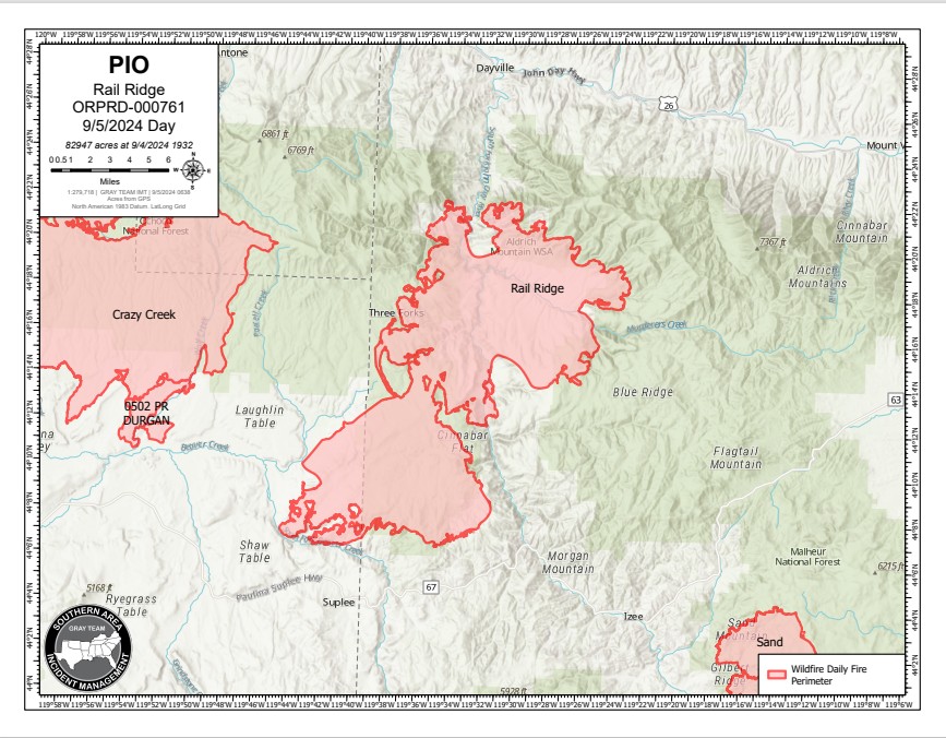
Dayville, Oregon — The Rail Ridge Fire started near the South Fork of the John Day River around Martin Creek and quickly moved into the Murderers Creek drainage. Several lightning-caused fires combined with the Rail Ridge Fire. Wildfires designated as 778 Fire, 761 (Rail Ridge) Fire, 779 (Powell) Fire, and 796 (Black Canyon) Fire are now being managed as one wildfire response. Full suppression strategy will be used where possible and with firefighter and public safety in mind.
Yesterday’s Activities – Firefighting operations focused on aggressively building fire perimeter where safe for fire personnel. Natural barriers, existing roadways, and established fuel breaks continued to be utilized to stop or slow spread along the perimeter of the fire.
Conditions remained too smoky for aircraft operations, but smoke shading and light winds provided opportunity to make progress in slowing fire spread and establishing control lines for upcoming operations. Strategic burning operations were utilized to remove unburned fuels between defensible barriers and the active fire front.
- On the north part of the Rail Ridge Fire, the focus was stopping the fire from spreading into the Deep Creek drainage to keep the fire away from structures in this area.
- Along the west side of the Rail Ridge fire, firing operations were used to connect lines that were built over the last few days. Crews continued strategic structural point protection, as safe to do so, while continuing to stop the fire’s spread along these planned lines.
- On the south part of the fire, similar operations to the western side were put in place. Rangeland Fire Protection Association resources provided dozer support to build lines.
- On the east side of the fire, structure protection and firing operations were also used to slow the spread of the fire. Mechanical equipment was used to reduce fuel loading along planned control lines.
Today’s Activities – Firing operation on the eastern flank may create smoke visible from nearby areas. More crews, engines, and heavy equipment will be arriving today. Firefighters will continue to focus on building new line where needed and strengthening the existing fire barriers that have been established. State, local, and federal resources are working in the north side to control the fire spread and establish structure protection. Smokejumpers were sent to Aldrich Mountain to secure the communication site.
Weather – A warming and drying trend will continue to dry out fuels, further increasing the likelihood of new ignitions and active fire behavior. For Friday, the temperatures will be in the high 90s with continued low moisture levels.
Evacuations —
- The Crook County Sheriff’s Office has lowered evacuation levels from Level 3 to Level 2 in areas south of Highway 380. However, areas around SE Puett Road and the perimeter of the Crazy Creek Fire remain under Level 3 (Go Now) status. For the latest updates, visit the Crook County Emergency Management website and Crook County Sheriff’s Office Facebook page.
- Wheeler County: The Wheeler County Sheriff’s Office continues to monitor fire activity. The area near Beaver Creek Road remains at Level 2 (Be Set), with areas around the fire perimeter still under Level 3 (Go Now) orders. Visit the Wheeler County Sheriff’s Office Facebook page for real-time updates.
- Grant County: A Level 3 “Go Now” alert remains in effect for areas around the Rail Ridge Fire, with Level 2 “Be Set” and Level 1 “Be Ready” advisories for other areas. For the most up-to-date evacuation information, visit the Grant County Emergency Management Facebook page.
- Please contact your local Sheriff’s Office to sign up for evacuation alerts.
Closures:
- The Malheur National Forest has implemented a partial closure order for the Blue Mountain Ranger District.
- The Ochoco National Forest has implemented a partial closure order for the Paulina Ranger District.
- The Bureau of Land Management has implemented a partial closure for lands managed in the Paulina Valley area.
- Oregon Department of Fish and Wildlife has implemented closures of the Phillip W. Schneider Wildlife Area.
- Visit the Oregon Department of Emergency Management website to view a map of active fires, evacuation alerts and closed areas.
Fire Restrictions –
- All public lands in Central Oregon, including the Ochoco National Forest, are in Stage 2 Public Use (Fire) Restrictions. All open fires, including woodstoves and charcoal briquette fires, are prohibited.
- Malheur National Forest is in Public Use Restrictions Phase C and can be viewed on the Forest’s website.
More Information:
InciWeb: https://inciweb.wildfire.gov/incident-information/orocf-rail-ridge
Facebook: https://www.facebook.com/profile.php?id=61565474339343
Visit the official source for wildfire information in Central Oregon at centraloregonfire.org for wildfire updates or follow fire information on X/Twitter @CentralORfire. Call 9-1-1 to report a wildfire. Smoke from the Rail Ridge Fire continues, and maps and air quality information are always available on https://fire.airnow.gov/. Please help firefighters by following all local regulations, found here: https://www.oregon.gov/odf/fire/pages/restrictions.aspx. Additional wildfire prevention tips are available at www.keeporegongreen.org.