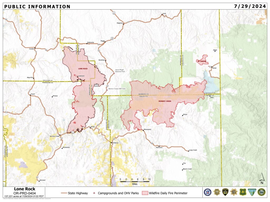
Location: Lonerock, Ore. to west of Highway 207| Size: 137,214 acres | Containment: 77% | Cause: Under Investigation | Start Date: July 13, 2024 | Total Personnel: 721
InciWeb: https://inciweb.wildfire.gov/incident-information/orprd-lone-rock-fire
Fire Information Line: 541-208-4369 | Email: [email protected]
Condon, Ore. — The Lone Rock Fire is being managed under a full suppression strategy by Northwest Incident Management Team 2 (NW2).
Yesterday’s Activities: Another 4.5 miles of containment line was added to the map yesterday, bringing the total containment to 77 percent. There is still a heavy presence of resources working to reinforce containment features along the fire perimeter. Various mop-up techniques were utilized across the fire area today, including the use of backpack fire pumps, or “bladder bags.” These devices allow firefighters to use water suppression for smaller scale burns, and in areas that are particularly difficult to access by vehicles.
Crews continue to patrol established containment lines and had no issues to report.
Today’s Activities:
Crews will continue mop-up work on the west side of the fire and on the east side in forested timberland. Minimal fire behavior is anticipated today as a cold front with the possibility of moisture moves through the area this afternoon.
With containment increasing daily, crews will be beginning preparing for suppression repair. Suppression repair consists of returning the disturbed areas, fire lines, staging areas, helipads, etc. to as natural a state as possible to minimize any future erosion damage.
Removal and chipping of standing dead “snag” trees will continue today with an emphasis along the Forest Service Road (FSR) 21 and FSR 25.
Evacuations:
- For Gilliam County evacuation information, visit Gilliam County Sheriff’s Office Facebook page.
- For Wheeler County evacuation information, visit Wheeler County Sheriff’s Office Facebook page.
- For Morrow County evacuation information, visit Morrow County Sheriff’s Office Facebook page.
Closures:
- For updated road closure information, visit https://www.tripcheck.com/.
- Umatilla National Forest Order Number 06-14-02-24-02 includes prohibitions within the Heppner Ranger District on the Umatilla National Forest.
- Bureau of Land Management (BLM) Prineville District Office issued an Emergency Public Land Closure on BLM-managed lands along the main stem John Day River and along the North Fork John Day River from Kimberly, Ore. to Dale, Ore.
Weather: A cold front will move through the area on Monday afternoon. Moisture associated with the front will bring cloudy skies by the afternoon with a chance for precipitation, including a slight chance for scattered thunderstorms after 2:00 p.m. There is a 30 percent chance for measurable rain on the fire Monday night, but a wetting rain is unlikely. Temperatures are expected to range from the mid-70s on the ridges to the 80s elsewhere with higher relative humidity values in the upper 20s to lower 30s that will continue to increase into Monday night. Light and variable wind becoming west at 6 to 11 mph in the morning, with gusts as high as 20 mph.
Smoke Information: Visit https://fire.airnow.gov/ for local air quality information.
Flight Restrictions: A Temporary Flight Restriction (TFR) is in place above the Lone Rock Fire area.