498/Kitty Creek containment increases as national resource limitations and extreme fire behavior continue to challenge firefighters on the Crazy Creek fire
Fire Information Phone: 541-208-1768 (8am-8pm)
Media Information Phone: 541-208-1770 (8am-8pm)
Email: [email protected]
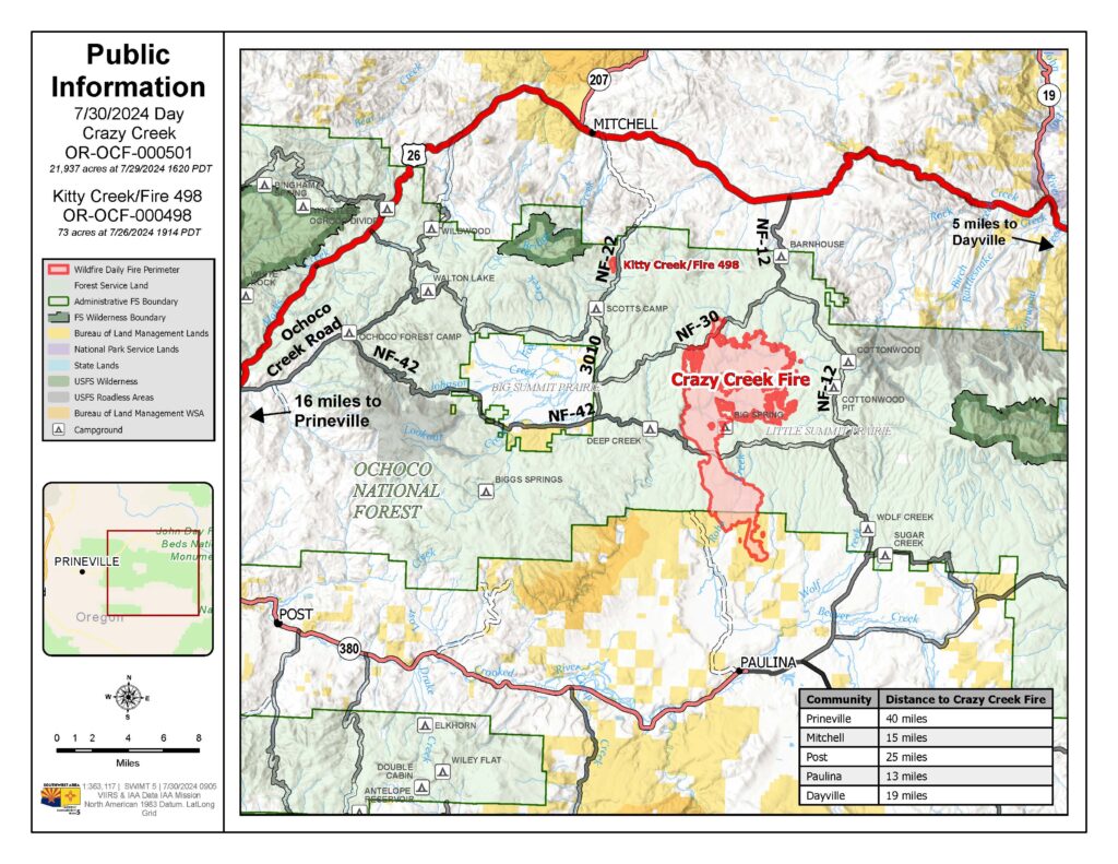
Acres: Crazy Creek – 21,937; 498/Kitty Creek – 73 Start Date: July 22, 2024
Location: Crazy Creek:16 miles north of Paulina, OR Personnel: 302 total for both fires
498/Kitty Creek: 7 miles south of Mitchell, OR
Containment: Crazy Creek 0%; 498/Kitty Creek 86% Fuels: Timber and short grass
Resources: 8 crews | 21 engines | 5 bulldozers | 6 water tenders | 1 masticator | 6 skid steer
Highlights: As containment on the 498/Kitty Creek Fire increases significantly, dry, hot conditions continue to challenge firefighters on the Crazy Creek Fire. The national preparedness level (PL) and Northwest geographic area remain at a PL5 – the highest preparedness level on the National Interagency Coordination Center (NICC) rating system. In PL5, national resources are heavily committed, causing challenges for incident staffing and filling of necessary resource to respond to dynamic fire situations, such as those on the Crazy Creek fire.
Fire Activity: Fire reached Moccasin Ridge on the southern end of the Crazy Creek fire and extended 1/ 4 mile south of Forest Road 30, east of Happy Camp Creek. Creeping fire activity was observed in the mixed conifer and lodgepole pine stands on the northern/northeastern flanks of the Crazy Creek fire as well as through the heavy dead/downed fuels. Slow, steady fire progression occurred north along Double Corral Creek, reaching the dozer-constructed containment lines near Toggle Creek and continued northeasterly, progressing along Thornton and West Thornton creeks.
Tuesday, crews on the north end of the Crazy Creek fire will continue to prepare containment lines while monitoring fire progression and initiating firing operations as needed and when safe to do so. In the northeast, efforts will continue in Toggle Meadow, where hand crews and dozer operators will construct containment lines around the private land. Crews on the south end will continue constructing direct fire line on the southwest side of the fire and will continue indirect line construction on the southeast side of the fire. As the week progresses, the region will experience hot, dry conditions. With the incoming drying trend, primary fire growth is expected to occur in grass and timber with more extreme behavior, such as heavy torching, and increased fire spread due to short-range spotting in the mixed conifer forests of the fire area.
Crews on the 498/Kitty Creek fire will continue to patrol and monitor the fire perimeter to further increase containment.
Evacuations: LEVEL 3 evacuations in the Ochoco National Forest have been expanded to the eastern boundary of Big Summit Prairie and south of the Forest boundary. Crook County has extended LEVEL 3 (GO status) evacuations to the south. As of now, Hwy 380 is the dividing line between LEVEL 3 and LEVEL 2. Camp Creek Road east to SE Beaver Creek Road north to the Forest Boundary, and east to the county line has been increased to LEVEL 3. The areas south of Hwy 380 from Camp Creek Road east, east side of SE Beaver Creek Road to the Forest Boundary, and east to the county line is at LEVEL 2. Wheeler County evacuation zone WHH-019C-B is in GO status.
Weather: Cooler temperatures will continue on Tuesday, with a chance of showers in the morning and temperatures in the low-high 70s and wind gusts up to 20mph. A shift is expected mid-week, bringing with it warmer temperatures and dryer conditions across the 498/Kitty Creek and Crazy Creek fires.
Importance of Fire Prevention: All public lands in Central Oregon, to include the Ochoco National Forest are in Public Use (Fire) Restrictions. All open flames, including woodstoves and charcoal briquette fires are prohibited. In times of high fire danger, it is crucial for everyone to follow fire prevention measures to avoid additional strain on overburdened resources. The public’s cooperation in adhering to fire bans and restrictions is vital to prevent new fires from starting and to help our firefighters focus on containing the existing fires. Learn more at https://www.fs.usda.gov/alerts/ochoco/alerts-notices/?aid=89068.
Smoke: Smoke from multiple fires in Central Oregon are impacting the region. Additional details are available via https://outlooks.wildlandfiresmoke.net/outlook/079f0f73.
Fire Restrictions and Closures: The Ochoco National Forest has implemented a forest closure for the Paulina Ranger District. More information can be found at fs.usda.gov/alerts/ochoco/alerts-notices/?aid=89203.
More Information:
InciWeb: https://inciweb.wildfire.gov/incident-information/orocf-crazy-creek
Facebook: https://www.facebook.com/SWIMT5
Central Oregon Wildfire Information: https://centraloregonfire.org/
Crook County Emergency Information Map: https://arcg.is/1ij0vb