Fire Information Phone: 541-208-1768 (8am-8pm)
Media Information Phone: 541-208-1770 (8am-8pm)
Email: [email protected]
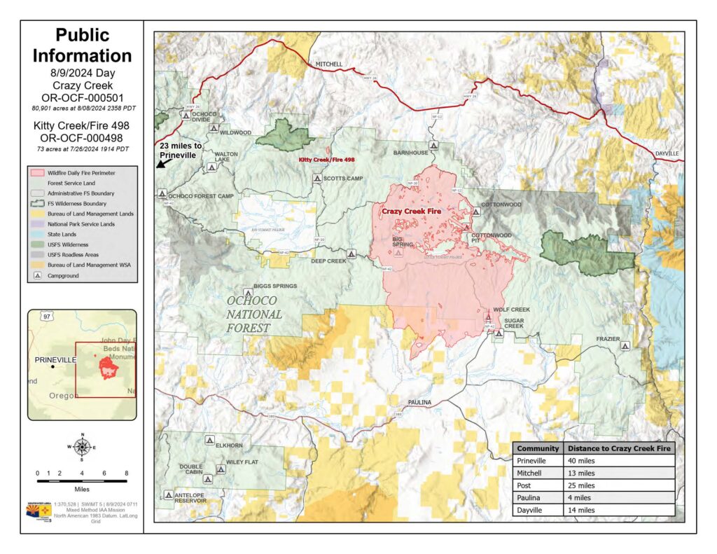
Acres: Crazy Creek: 79,971 | 498/Kitty Creek: 73
Start Date: July 22, 2024
Location: Crazy Creek: 5 miles north of Paulina, OR | 498/Kitty Creek: 7 miles south of Mitchell, OR
Personnel: 638 total for both fires
Containment: Crazy Creek: 50% | 498/Kitty Creek: 100%
Fuels: Timber and short grass
Highlights: Clouds and smoke sat heavy on the fire area throughout the morning on Thursday, August 8. As smoke lifted by mid-afternoon, fire activity increased with crews observing group tree torching and short-range spotting. Short uphill pushes were also observed in several areas where fuels and drainages aligned, including Bear Mountain and through East Wolf Creek.
Fire Activity: On Thursday, August 8, crews built on the success of overnight firing operations in the north/northeast area of the Crazy Creek Fire to reduced fuels and secure containment lines. On the northwest portion, spot fires are fully contained.
Today, firefighters will patrol and mop-up along the northern perimeter. Along the western perimeter, remaining heat sources within Deep Creek drainage are being monitored and firefighters and working to hold and secure the fireline in that area. Resource advisors have begun assessing suppression repair needs and crews will also assess heavy equipment needs and determine a plan for relocating remaining log decks from the northwest area of the fire. Crews will complete prepping the final mile of Forest Road 5820 on the eastern perimeter to protect recreation infrastructure.
Evacuations: Evacuation orders remain in effect for areas in Crook and Wheeler Counties for areas in or near the fire. Level 3 evacuations have extended from the Forest Boundary to Highway 380. Level 2 evacuations have extended south of Highway 380. For further information, please refer to the Crook County Office of Emergency Management evacuation map.
Weather: Hot, dry weather will continue through the weekend across the region with temperatures in the high 80s to low 90s, light wind and low humidity.
Importance of Fire Prevention: All public lands in Central Oregon, to include the Ochoco National Forest are in Stage 2 Public Use (Fire) Restrictions. All open flames, including woodstoves and charcoal briquette fires are prohibited. In times of high fire danger, it is crucial for everyone to follow fire prevention measures to avoid additional strain on overburdened resources. The public’s cooperation in adhering to fire bans and restrictions is vital to prevent new fires from starting and to help our firefighters focus on containing the existing fires. Learn more at https://www.fs.usda.gov/alerts/ochoco/alerts-notices/?aid=89068.
Fire Restrictions and Closures: The Ochoco National Forest has implemented a forest closure for the Paulina Ranger District. More information can be found at fs.usda.gov/alerts/ochoco/alerts-notices/?aid=89203. Bureau of Land Management has issued a temporary closure for public lands in Crook and Grant Counties. More information is available at https://www.blm.gov/sites/default/files/docs/2024-08/orwa-fpo-pri-paulina-080224.pdf.
More Information:
InciWeb: https://inciweb.wildfire.gov/incident-information/orocf-crazy-creek
Facebook: https://www.facebook.com/SWIMT5
Central Oregon Wildfire Information: https://centraloregonfire.org/
Crook County Emergency Information Map: https://arcg.is/1ij0vb