Quick Facts: Bachelor Complex
Size: 10,332 acres Start Date: Sept 8, 2024 Location: Mt Bachelor, 20 miles SW Bend, OR Personnel: 248
Quick Facts: Firestone & Flat Top Fires
Firestone Size: 8,787 acres Start Date: Sept 6, 2024 Location: North of Fort Rock, OR
Flat Top Size: 30,643 acres Personnel: 116
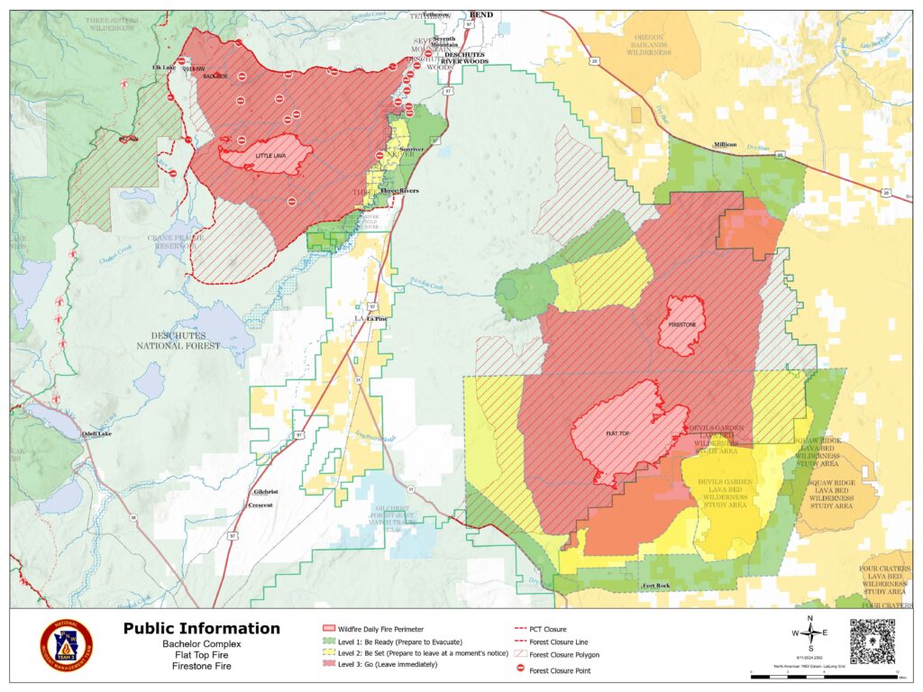
Yesterday firefighters continued to work on suppressing the Bachelor Complex, Flat Top and Firestone Fires which saw slow to moderate growth on Wednesday due to cooler, wetter weather. This decrease in fire activity allowed crews to focus efforts on putting in containment lines on the fires. A helibase was established in Sunriver to support aerial resources. Firefighting operations include connecting roads with dozer lines and handlines both directly adjacent to the fire and further away, where indirect strategies are more effective. No new fires were reported on Wednesday. Today, firefighters will work on structure protection in the vicinity of Sheridan Mountain and west of Sunriver. Firefighters will continue to establish and secure containment lines around the Bachelor Complex, Flat Top, and Firestone Fires. Aerial resources will continue to help with suppression efforts.
Bachelor Complex: The Bachelor Complex is a group of about 30 fires that range from one tenth of an acre to over 9,500 acres, for a total of 10,332 acres. The cooler wet weather slowed fire spread on the Little Lava Fire and crews capitalized on the opportunity, making good progress toward securing the fire’s edge east of Forest Service Road 45 with dozer line. Moderated fire behavior is expected again today, and firefighters will continue those efforts. They are using Forest Service Road 4525 to connect roads and trails to serve as containment lines. The Backside, 911, and 892 Fires are higher up on the Cascade Crest and received almost one tenth of an inch of precipitation yesterday. Today, firefighters will continue to secure and mop up the Backside Fire and smokejumpers continue to mop up the 911 Fire.
Flat Top Fire: Yesterday, firefighters were able to directly engage putting fire on the ground to help secure control lines on the north and northeast sides of the fire. The crews working overnight reported no increase in size for this fire. Today, firefighters will continue work on securing the north side and conduct lighting operations off of Forest Service Road 22 to strengthen containment lines by consume vegetation between the line and the active edge of the fire.
Firestone Fire: Yesterday, firefighters were able to get most of the western edge of the fire secure. They used hand and dozer lines to stitch together a containment line with the existing road system. Work will continue securing the north side of the fire.
Safety: With increased fire traffic, everyone in the area is reminded to drive slowly and carefully in evacuation areas. If you don’t need to be in the area, please stay clear to allow firefighters plenty of time and space to work.
Weather and Fire Behavior: Bachelor Complex fires received more rain than Flat Top or Firestone Fires yesterday. The amount of precipitation on the Little Lava Fire was not enough to have long-lasting effects. Vegetation beneath the tree canopy remains dry and ninety percent of this fire has an active perimeter. The Backside, 892, and 911 Fires received more moisture which significantly slowed fire spread. Based on the weather outlook for the higher elevation fires on the Bachelor Complex, fire behavior analysts predict another mild day for fire behavior. On the Flat Top and Firestone Fires, stumps and logs are expected to continue burning while grasses and shrubs aren’t expected to dry out enough to be receptive to ignition until this afternoon. Scattered showers are expected throughout day over all fires.
Evacuations: Emergency management and fire officials are closely coordinating and adjusting evacuation levels as needed. Level 3 evacuations mean “Go Now,” Level 2 means “Be Set,” and Level 1 means “Be Ready.” To view current evacuation levels, please visit the Deschutes County Emergency Information Interactive Map at: http://www.deschutes.org/emergency. For Lake County evacuation information, please visit: https://www.lakecountyor.org/flat_top.php
CLOSURES: There are two closure areas on the Deschutes National Forest for these fires. View the orders on the Deschutes National Forest site at: https://www.fs.usda.gov/alerts/deschutes/alerts-notices .
Facebook: https://www.facebook.com/deschutesnationalforest/
InciWeb:
https://inciweb.wildfire.gov/incident-information/ordef-bachelor-complex-fireshttps://inciweb.wildfire.gov/incident-information/ordef-flat-top-and-firestone-fires
Fire Information Line: 541-249-9829, 8:00 a.m. to 8:00 p.m.